If you do not feel comfortable with an overnight at Crater Camp (18,500') and want a longer and more remote trek experience than the 7-day Machame Route, the 8-day Lemosho-Stella Point Route is the answer!
This route is very special for several reasons:
- It is a combination of the best features of the Lemosho and Machame routes! You get to view the Lemosho forest, the Shira Plateau, Lava Tower, the Western Breach from a safe distance, the dramatic Barranco Wall, the beautiful Karanga Valley and the Mweka rain forest.
- It is safer than the normal Western Breach approach and less crowded than the standard Machame route.
- Everybody can do it! It is very satisfying and breathtakingly beautiful.
Itinerary
At breakfast we drink as much water as we can!
After breakfast, we drive north east to the town of Londorossi where we must complete some paperwork at the warden's office. Then we drive for another hour on a muddy and slippery road to the starting point at Lemosho where our porters are waiting.
While one of our guides stays behind to organize the porters, we begin our trek around noon at an altitude of 7500 ft. The walk is absolutely beautiful and our pace is slow to assist with acclimatization. Along the way we may see fresh elephant dung! Fortunately these elephants are very elusive!
The guides will stop frequently to point out some interesting plants. We identify many different kinds of trees such as juniper, olive and Nuxia congesta.
The scenery will change often; at some points the forest is thick and dark. In open areas we may see a few colorful flowers!
The trail is slippery when it rains so we walk carefully. Every now and then our legs get scraped with nettle plants. Some climbers develop a rash so we recommend you wear long pants during today's hike. Also watch the ground for safari ants. Their bites burn! Stamp your feet when you're near ants and roll your socks over your long pants.
An hour or so after starting the climb, we stop for lunch. You will be surprised at the feast that awaits you! A lunch buffet table, comfortable chairs, a portable toilet. This is Taraji-style and it's much appreciated.
The rest of the climb is mildly strenuous at times but the hills are short. Some of the downhill stretches are quite steep so we use our poles to prevent us from slipping and sliding!
Don't forget to take pictures! The forest is now at its most beautiful.
We continue to climb slowly and reach our camp about 2 hours after our lunch stop.
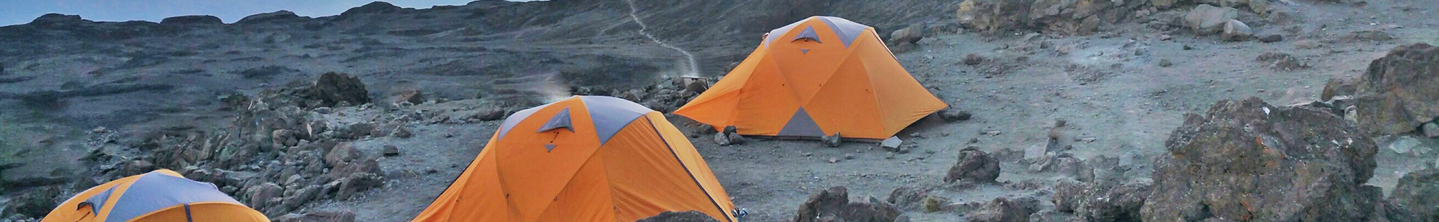
Our camp is in the montane forest at 9,000 ft. Everything will be ready for our arrival. Tonight we will have about an hour or so before dinner, so we have some time to get organized for the evening.
We must eat well tonight. At the higher altitudes we may lose appetite so these first few days are important for building up energy reserves. We must also drink at least another liter of water before going to bed.
Darkness comes early in the forest and the clear sounds of the night remind us that we are far away from home. We are finally camping on the slopes of Kilimanjaro!
The hike from the Forest Camp to our lunch stop is easy. After lunch, we will hike mostly uphill for long steep stretches until we arrive at the Shira Ridge. The last hour will be an easy stroll across the plateau.
We start off with a short steep climb. In the early morning the colobus monkeys are noisy but they are hard to spot! After about 2 hours we stop for a quick snack— we eat energy food such as peanuts and chocolate bars.
Soon afterwards, the forest clears and we enter the heather zone. We see plants such as Erica arborea and Philippia excelsa. This is a good time to cover up with sunscreen as the temperature often reaches a sunny 75º F or warmer.
In this area we may see illegal beehives. Beekeepers often set the forest on fire (by accident) when they create smoke, so they've been banished!
The ground vegetation continues to change and new types of plants appear around every corner. Look for the chair-like tussock grasses!
In the open landscape we can now see the trail ahead as it winds along the ridges of Shira. It is clear that we have some hiking to do before this day is over!
About 3 hours after leaving Forest Camp, we will reach the top of a hill where we can see our lunch stop in the clearing below.
The downhill walk is pleasant and we increase our pace a bit because after lunch, we will hike mostly uphill along the Shira ridges.
We reach our lunch stop around noon. It is time to kick back and enjoy the beautiful surroundings. This is another opportunity to eat and drink as much as we can.
After lunch we immediately start a very steep hike for about 30 minutes, and then we follow one ridge after another—hiking higher and higher as we get closer to the upper slopes of Shira.
Behind us, clouds may start to roll in—a common afternoon occurrence on Kilimanjaro.
Around 2:30pm we reach the high-point of the day and turn west for an easy 20-minute walk to the western edge of Shira. Suddenly, on the right, we see Kibo for the first time!
To the north and north-west, we see the Shira Plateau and we take a short rest and photo opportunity before we hike the final stretch across the plateau to Shira 1 Camp at 10,965 ft.
We reach camp around 4pm. In the late afternoon the clouds often clear away and we are treated with a magnificent view of the Western Breach in the distance!
Today's hike is nor very long with just one steep section at the end of the trek. The Shira Plateau is truly beautiful with interesting plants, rock formations and several water streams.
When we wake up this morning we will see the sun rise behind Kibo, and this magnificent view will be in front of us all day. We start with a very short climb before the trail flattens out for a very pleasant walk.
To our right, we can see the Shira Cathedral and behind us the Shira Ridge will slowly fade into the distance.
We are hiking at an altitude of 11,500 ft but most climbers have no problems with this part of the trek.
Early on in the day we cross a refreshing stream, reminding us to stop frequently and enjoy the beautiful scenery. Then it's a short uphill walk to a section that reminds us of the heather zone of yesterday. We are now in an area well-known for eland and buffalo, so we look for fresh tracks.
Soon we cross back into moorland and the lava ridges of Kilimanjaro are now closer in front of us. Our next camp is on the first major ridge, but we still have another 2-3 hours to go!
On the left, we follow a stream with many caves. In the old days, this was lion country and the caves were lion hideaways.
We also see a 4x4 track used by the rescue vehicles.
Around noon we find ourselves in senecio country! We always stop to take pictures of the majestic Senecio Kilimanjari which grows into a small tree up to 15 ft high.
A bit further up the hill we see our first Lobelia Deckenii. To protect their sensitive buds in the central core, the outer leaves close at night!
Around 1pm we reach the top of the ridge in time for lunch. The views are spectacular! We are at Fischer Camp, so named in memory of the American guide who died on Everest but who was one of the first guides to explore the Western Breach of Kilimanjaro.
We are at 12,230 ft. We eat lunch and visit the Fischer memorial before continuing the trek for another 2 hours to our overnight stop. Along the way we have one rather steep section but there are several flatter areas to save some energy!
Once we are beyond the steep section, we hike next to a dramatic rock section with caves and overhangs.
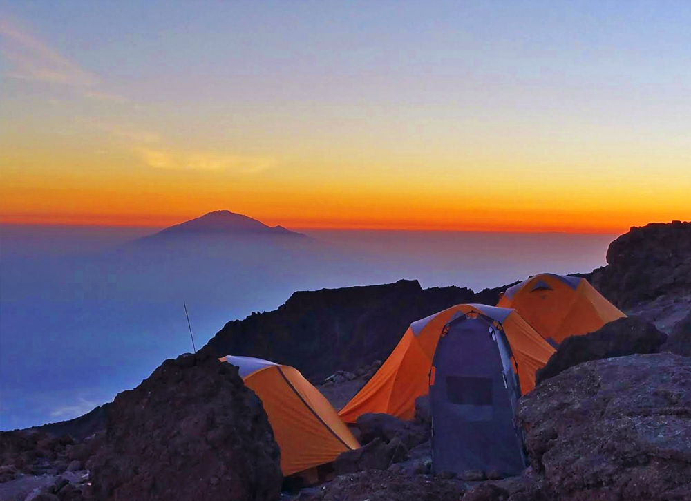
Soon afterwards we see a strange structure to the northwest in the distance! This is an old hut at Moir Camp - our stopover.
Moir Hut is at 13700ft (4175m). It is about 3pm—time to take a shower and a well-earned rest.
Today's hike to our camp Barranco via Lava Tower is long and it's steeper than yesterday with at least 2 long uphill sections and a major downhill.
The day starts with a short steep section. Due to the altitude, some climbers will feel less energetic than yesterday! It is time for energy drinks and bars.
As the sun rises higher, the views are stunning. Looking towards Kibo we can see the trail ahead crossing several ridges and valleys. Behind us, the Shira Ridge, Shira 1 and Fischer Camps are fading in the distance.
After an hour or so, Mount Meru appears in the distance. We get an idea of how far away we are from Arusha!
After the initial few ridges, the scenery starts to change. We are leaving the moorland and are now in the alpine zone. These are inhospitable conditions where it freezes every night. Plant life is reduced to mosses, lichens and a few everlasting flowers.
The trail can now get very dusty and we spread out a bit to avoid each other's dust! Wet bandanas and wet wipes come in handy to keep our faces clean!
The first of a few long uphill stretches awaits us about an hour into the trek.
As we slowly make our way uphill, we can see the Machame route camp sites. Using binoculars, we can see a long stream of porters and trekkers leaving these camps for the Lava Tower area.
The long uphill hike continues to a point where our trail meets up with the Machame route. Here we take a break while watching many large groups walk by. It is strange to see so many other climbers. Until now we basically had the mountain to ourselves!
After the break, we follow the convoy of trekkers and porters to Lava Tower.
Along the way, we climb down a steep gap in the rocks before we reach the final uphill stretch of the day.
The last uphill walk is long and seemingly never-ending! But then we see the recognizable shape of the Lava Tower and we are only a few hundred yards away from our lunch stop.
We reach Lava Tower around 1pm. We are at the highest point of today's walk - 14,850 ft or 4530m. Some will start to feel the altitude in the form of a mild headache.
Others may want to climb the Tower - a 30 minute climb that has its moments. In two places it is best not to look down! But the views from the top are well worth the effort.
A 45-minute lunch is served next to the tower. From here it is almost all downhill to Barranco camp!
After lunch, we take our time descending into the Great Barranco valley. We see plenty of senecio and lobelia plants.
It is very steep in some areas and we use our walking poles to steady ourselves. This is not the time to hurt an ankle or knee.
At 4pm we reach Barranco Camp at 13,054ft (3978m). This is a beautiful camp with the dramatic Barranco Wall looming large to our east.
Today's hike to the Karanga Valley is short but crucial for proper acclimatization. Some outfitters bypass the Karanga camp and head straight for Barafu Camp—not recommended!
Just north of camp, we cross a small stream before starting the long scramble to the top of the Barranco Wall (also known as the Breakfast Wall). The scramble looks more intense than it really is.
Nevertheless, it takes about 75 minutes to reach the top of the wall. We will rest for 15 minutes and take plenty of pictures. The Barranco camp is just a small dot in the distance!
From here, we cross a series of hills and valleys until we descend steeply into a valley with several water streams.
The final hill to camp is very steep!
We reach Karanga Valley camp around 1:30pm.
We overnight here at 13,277ft (4046m). In the afternoon, we have plenty of time to relax and rest.
We continue our uphill climb across barren landscape with lots of boulders and shattered rocks. It is very quiet and peaceful. The Decken Glacier is always presence to your left.
Before we know it, we are standing on a ridge looking across a valley towards Barafu Camp in the distance!
After a slow hike up that final hill, we reach a fork in the trail - the way down to Mweka is to the right. We will go left, following a very steep ridge until we reach a rocky section for some more scrambling.
20 minutes later we reach our camp amidst large rocks with dangerous cliff-faces. We need to be careful here - some climbers have been killed when they lost their way during the night while looking for the long-drop toilets.
It is smart to take an acclimatization hike with our guides in the afternoon.
Tonight most climbers in camp will go to bed early (7pm) as the wake-up call is 11pm for our summit assault!
Overnight at Barafu Camp at 15,200ft (4600m).
For all, this is the day they've been thinking about.
Climbing the last long stretch to the Crater Rim area in the freezing cold and dark will be a mental and physical challenge that few will ever forget.
The day starts with a wake-up call at 11pm. As we stumble into the cold night air, the first thought is that this may be impossible. Then the adrenaline takes over and our moods quickly change from angst to anticipation.
After a quick hot beverage and snacks, we line up to follow our guides into the darkness. Ahead we may see a long line of lights from other climbers on the same quest.
We start before midnight and immediately do some light scrambling over a rocky section just above Barafu Camp.
After an hour or so the rocks give way to gravel and firm scree and we start our traversing hike that will continue for four hours. Along the way we take many short breaks to drink water and to rest.
Please remember, in the cold it is better to keep on moving—you don't want your body to get cold.
As the hours tick by, we start to learn about ourselves. There is little talk between us; every person is busy with his or her own thoughts. At times it is tempting to give up. We see many others sitting down and we several climbers who decided to turn back.
Along the way we pass slower climbers and we get passed by stronger ones.
We must not get discouraged about our slow rate of progress. For many, it simply a case of 5 or 6 steps forward, followed by a short rest and then a few steps forward again. This is normal. As long as we keep on moving we are in good shape.
Our guides will encourage us with positive words and by singing songs in Swahili. Before too long, we can see the sun slowly rising behind Mawenzi.
About an hour or so before sunrise we should find ourselves below Stella Point with a really tough and slippery stage ahead of us. It is 3 steps up and 1 step back as we slide on the scree.
45 minutes later, at Stella Point, we take a short rest and a photo at the Stella Point sign then we slowly proceed with the hour-long uphill hike to the summit (arriving between 7-8am).
The moment we arrive at Uhuru Peak is a wonderful occasion that we will never forget! Some will cry, others will quietly take in the moment.
We have done it!
After a cold night but fantastic scenery as the sun rose over Mawenzi, and an incredible 30 minutes at the summit, we gather ourselves for the downhill walk to Stella Point!
It takes about 20 minutes from the summit to Stella Point where we may still see climbers arrive in zombie-like conditions! In the daylight the uphill hike from Barafu to Stella Point looks very steep!
Be prepared for a shock - the way down is a steep, rigorous route from Stella Point down the mountain to Barafu where we stop for lunch. Adjust both your poles to long.
At Stella Point, consider removing your warmer outer layers and make sure your gaiters are properly tied to prevent sand from entering your boots.
Many hikers are unprepared for this 4-hour ordeal down the slippery slope of scree. Don't be. The sun will beat down and we will soon curse our 4-layers of summit wear!
We sweat and eat dust like rodeo cowboys! It is rough going!
At Barafu we take a good rest before tackling the rest of the way down. Some people try to sleep a bit. We think it is better to keep on going.
The day is clearly not over yet. We must continue down the mountain for another 3 hours of serious downhill walking.
We reach Mweka Camp in the late afternoon, and scramble to be first in the shower (if provided by the outfitter)!
Dinner tonight is a joyous celebration with local cuisine!
Sadly, it is our last night on Kilimanjaro. We are at 10146ft (3092m).
Breakfast is served at 8:00 and we depart at 9:00am.
Today is a surprisingly challenging and steep downhill walk through the rainforest to the park gate.
When it rains, the trail is muddy and very slippery. We use our poles to prevent knee or ankle injuries.
There are many other climbers on this trail and plenty of stories and experiences to share. It is noisy all the way to the gate—arrival at noon!
At the gate, we are treated with a final feast of fruits and drinks, and an opportunity to buy a few souvenirs! Then we sign the register and gather for the presentation of our climbing certificates by our guides, followed by a short tipping ceremony.
Sadly, it is time to say goodbye to our mountain team. With their assistance, we achieved something extraordinary !
Our cars are waiting and we wave teary-eyed goodbyes to our porters.
Our Kilimanjaro experience is over!
We hike 5.5 miles (8.55km) from Mweka Camp to the gate at 5360ft.
Breakfast is served at 8:00 and we depart at 9:00am.
Today is a short but steep downhill walk through the rain forest to the park gate.
When it rains, the trail is muddy and very slippery. We use our poles to prevent knee or ankle injuries.
There are many other climbers on this trail and plenty of stories and experiences to share. It is noisy all the way!
At the gate, we are treated with a final snack and drinks, and an opportunity to buy a few souvenirs! Then we sign the register and gather for the presentation of our climbing certificates by our guides, followed by a short tipping ceremony.
Sadly, it is time to say goodbye to our mountain team.
With their assistance, we achieved something extraordinary! We climbed Mount Kilimanjaro - the highest freestanding mountain in the world!